Blog
News, updates, finds, stories, and tidbits from staff and community members at KAHEA. Got something to share? Email us at: kahea-alliance@hawaii.rr.com.
- The 2006 HIMB expedition on the NOAA vessel, Hi`ialakai, was one of the first major expeditions permitted in the newly established no-take state Refuge for the Northwestern Hawaiian Islands.
- Despite a prohibition on the transport of live samples and the dumping of wastewater, state and federal officials noticed the researcher was transporting pieces of live coral over 100 miles across the multiple state and federal designated marine protected areas in an open-flow holding tank — a system that dumps used water from the tank back into the ocean.
- Official reports also allege she cultivated bacteria associated with coral disease while the ship traveled from Johnston Atoll.
- HIMB was not granted a permit to import coral or bacteria from Johnston Atoll to the Main Hawaiian Islands from the Agriculture Department. Nonetheless, the researcher was discovered to have bacteria samples from both NWHI and Johnston Atoll under cultivation on board the Hi`ialakai.
- The methods proposed by the HIMB disease researcher had also raised red flags in the scientific community. Before the vessel departed from Honolulu, scientific advisors reviewing the researchers proposal to import disease bacteria from Johnston Atoll to the Main Hawaiian Islands for the state Department of Agriculture noted “possible disastrous consequences” from the research methods, including the spread of potentially invasive coral species and coral disease.
- In their report, they discuss the “unclear scientific merit” of the research and found “little evident benefits from a conservation perspective.” They also expressed specific concerns about the proposed use of an “open flow” system for the transport of live samples and, instead, recommended that “all water in which the corals or microbes from them are held shall be kept in containers that do not release effluents into open or semi-open systems unless that water is sterilized or disinfected.”
Federal Court Issues Injuctions, Requires Navy to Do More to Protect Hawaii's Marine Mammals from Harmful Sonar
Hawai‘i federal district Judge David A. Ezra today found that the Navy is violating federal law and enjoined it from carrying out its Undersea Warfare Exercises in Hawai’i’s waters without adhering to additional mitigation measures to protect marine mammals. The Navy is also required to take a hard look at the impacts of its high-intensity, mid-frequency active (MFA) sonar by preparing an Environmental Impact Statement.
Earthjustice, on behalf of Ocean Mammal Institute, Animal Welfare Institute, KAHEA: The Hawaiian-Environmental Alliance, the Center for Biological Diversity, and Surfrider Foundation’s Kaua’i Chapter, sued the Navy last May. Judge Ezra issued a preliminary injunction after finding the Navy was violating the National Environmental Policy Act (NEPA) and the Coastal Zone Management Act (CZMA), and was likely to cause harm if allowed to proceed without greater protections.
He noted the Navy’s harm threshold—173 decibels (dB)—contradicts the best available science, and “cast into serious doubt the Navy’s assertion that, despite over 60,000 potential exposures to MFA sonar, marine mammals will not be jeopardized.” The Court said further the Navy had failed to analyze reasonable alternatives to conducting its exercises in the manner it proposed, failed to notify and involve the public as required by law, and failed to take into account the potential for serious harm from an exceptionally controversial activity.
Learn more about the lawsuit and the impacts of high-intensity mid-frequency (MFA) sonar on Hawaii’s marine mammals.
It's about respect, man.
From Miwa:
It’s true that the HIMB researcher currently under investigation for NWHI permit violations is coral disease researcher, and that coral disease is bad stuff. In doing this work, we’ve learned more about coral disease than we probably ever wanted to–coral disease is an important concern in our oceans worldwide.
So why advocate strict enforcement for a coral disease researcher?
What’s important to understand is that: It’s not just about understanding the ecosystem and its resources.
It is about achieving that understanding in a pono way–by researchers who respect the cultural and natural significance of the resource, take responsibility for their actions, and are committed to following the rules put in place to protect this fragile and uniquely Hawaiian place.
And so you have to ask: was this research done in a pono way?
We’re not the only ones for whom this stuff seemed just a little, er, inappropriate.
I come from a conservation and research background–and I admit that makes me feel a bit squirmy when the human footprint being talked about hits so close to home. This is a true test for all of us–for conservation and science communities–to recognize the scope of impact of our own activities. For a place as fragile, and as culturally and ecologically unique as the Northwestern Hawaiian Islands, this means taking a hard look at our attitudes, our institutions, our intentions, and our ambitions.
In the end, it’s really all about respect. It’s either there, or it’s not. Respect for rules, respect for the resource, and respect for the concerned public to whom this public trust resource ultimately belongs.
In her testimony to the BLNR on July 27, 2007, the HIMB researcher under investigation defended her actions, characterizing the violations as a “minor misunderstanding.”
“There was never any risk to the environment for what I did, whether it was approved or not,” she testified.
For the largest conservation area of its kind in the world, for the people who fought so hard for the rules protecting this incredible and untouched Hawaiian place, for all the future generations of Hawaiian people to whom this place also belongs… I have to believe that we can do better.
(top picture from http://news.bbc.co.uk/1/hi/5084944.stm, bottom from kahea.org)
State-Appointed Hearing Officer Affirms KAHEA's Standing in Historic Decision
Investigation of HIMB Research Permit Violations for Northwestern Hawaiian Islands Expanded,
Contested Case Hearing Officer Recommends Long-Time Advocate, KAHEA, Be Party to the Case
HONOLULU – In a historic move, citing KAHEA’s long history of actions to protect the NWHI, state-appointed hearing officer for the Board of Land and Natural Resources, Louis Chang, recommended on Friday that the Board grant KAHEA: The Hawaiian-Environmental Alliance standing as a party to a landmark case concerning the first recorded major violations of the state’s new stringent Northwestern Hawaiian Island Refuge rules. “The Northwestern Hawaiian Islands are a public trust resource, and we welcome this affirmation of our kuleana to ensure that the strict rules we worked so hard to establish are fully enforced so that this fragile and unique place is well-protected,” said Vicky Holt-Takamine, KAHEA Board of Directors President.
Federal and state officials have testified that in 2006, during one of the first major research expeditions permitted to conduct extractive activities in the state’s newly created no-take Refuge, scientists from the Hawai’i Institute of Marine Biology (HIMB) — including a former state Department of Land and Natural Resources employee –cultivated coral disease bacteria in the NWHI, transported bacteria within and outside of the NWHI, and attempted to bring bacteria cultures to the Main Hawaiian Islands, in violation of the state’s strict permit requirements and state and federal quarantine and customs laws regarding the transport and import of disease organisms. Officials testified that an HIMB disease researcher harvested, cultivated, and transported live coral within the NWHI, dumping wastewater from the coral tank overboard as they traveled between islands. These actions, which occurred in 2006, represent serious violations of state permit conditions designed to protect the NWHI from the spread of disease and invasive species, as well as state and federal laws.
The NWHI Refuge specifically establishes a ‘do no harm’ standard for all activities there,” said Louis “Buzzy” Agard, former NWHI resident who fished commercially there and later fought for strong conservation measures. “This should mean human activity in the NWHI is strictly limited so as to leave no human footprint on what is left of this delicate marine ecosystem.” According to Agard, “If this were a fishing violation, they’d throw the book at them. But this is a case of colleagues and friends of DLNR staff. There seems to be a double standard for these violators.”
Efforts by the Hawaii Institute of Marine Biology (HIMB) to block enforcement of strict state rules protecting the Northwestern Hawaiian Islands State Refuge were dealt a blow with the publication of the recommendation on Friday indicating that — as per KAHEA’s request — the investigation into apparently illegal activities would now be broadened and that KAHEA has standing in the case. There have been persistent rumors, however, of back-room attempts to lobby Board members regarding this case and to encourage DLNR to take extraordinary measures to overturn the hearing officer’s recommendation.
“This is historic,” said Miwa Tamanaha, Executive Director of KAHEA. “We have serious allegations of research permit violations in the face of more people and research vessels heading to the NWHI. What is decided here in this first enforcement action against research permit violations will affect all future decisions about how to fully protect this uniquely Hawaiian no-take marine environment.”
The Land Board is expected to rule on the recommendation March 7, 2008.
You can see the full case filings and get more information at www.KAHEA.org
(top photo from keoki, and bottom photo from kahea.org.)
our world gets bigger.
UPDATE from Rich on 2/29: Got word yesterday that the House Finance Committee passed HB839 with amendments!

From email from Rich ma over at Beach Access Hawai’i in Kailua:
I was going to use a clever subject line for this email — something like, “Show me the money!” because that’s what it comes down to now. We’re asking the State to pony up bucks to do this beach access survey and report. But a little earlier I got a phone call from someone in our group…
His mother passed away this morning and he wanted the phone number of another BAH member, because he needed help getting a canoe so he could scatter her ashes in the waters off the Mokulua islands. He said she loved Lanikai and Kailua Beach, and this is what she wanted.
Until I got involved with this cause, I didn’t know him or the paddler he wanted to get in touch with. I think it speaks volumes about what the beaches and ocean means to all who live in Hawaii. It connects us, and brings us together. You know those people who put up gates on “private” roads? Their world has gotten smaller, while our circle of friends is growing and getting bigger.
You can support the bill he’s talking about–HB839– by showing up to the hearing and/or emailing in your testimony to the finance committee. FINtestimony@Capitol.hawaii.gov (contact Rich at figeli001@hawaii.rr.com if you need sample testimony to follow.)
From BAH: The meeting will be in Room 308 at the State Capitol building. HB839 is at the top of the agenda, so testimony will probably start around 11:15 am, and could continue for a half hour to an hour depending on how many people show up.
Hero* (note the asterick)
From Marti:
Is Superman still a hero if he is the one pushing people off 50-story buildings before wisking them away to safety?
The U.S. Department of Defense seems to think so. According to them (and every major news source) the U.S. military successfully saved the world by blowing up the toxic satellite-fireball that was plummeting towards Earth last week. They would prefer we not dwell on the part about how it was THEIR spy satellite. That THEY launched and immediately lost control of. Loaded with THEIR toxic jet fuel. That they are pretty sure won’t rain fireballs down on us.
“By all accounts this was a successful mission. From the debris analysis, we have a high degree of confidence the satellite’s fuel tank was destroyed and the hydrazine has been dissipated,” Gen. James E. Cartwright, vice chairman of the Joint Chiefs of Staff said in a released statement. “The successful satellite engagement was truly a collaborative effort from across the U.S. government, the armed forces, industry and academia working together to reduce the risk to human life.”
See the full article, Honolulu Advertiser Online.
As I stood on the corner of Nu‘uanu and Pauahi Streets reading the headlines … “Direct Hit!” … “Mission Success!”… and wondering if that was rain or droplets of toxic fuel pinging my cheek, I thought: man, if ever a headline needed an asterick…
yes, it's happening. now DO something.
Bringing to your attention two articles on oceans in the Star Bulletin today:
Satellite images reveal trawling damage
A University of Hawaii zoologist is among a group of scientists decrying the destructive effects of bottom trawling, a type of fishing, visible in satellite images from space.
“Trawling removes much of the life from the sea floor,” said Elliot Norse, president of Marine Conservation Biology Institute, who participated in the session. “The effect is basically to denude the sea floor.”
He said bottom trawling catches more unwanted fish and does more harm to the sea floor than any other kind of fishing. The sediment disturbing the water column can also clog fish gills, possibly reintroduce absorbed carbon into the water and kick up toxic materials that have settled to the bottom, Norse said.
“Now we have images from space showing how much sediment it lofts into the water column,” he said. “Not just affecting the sea floor, it also affects the water column.”
Ten years ago, Norse and Watling completed a study that found bottom trawling covers an area the size of the continental United States every year.
Ocean Desert zone extends to Hawaii
The ocean’s dead zones have expanded in recent years to include part of the Hawaiian archipelago, scientists have concluded from space-observation studies.
The largest ecosystems in the major ocean basins are subtropical gyres, large-scale regions of winds and currents with low chlorophyll for plant and animal growth. These areas cover 40 percent of Earth’s surface and in nine years have expanded 10 to 25 times faster than global-warming models predict, the scientists said.
“What’s happening is, large portions of the area are becoming less productive,” said Jeffrey Polovina, with the National Marine Fisheries Service in Honolulu.
This will likely decrease the carrying capacity for larger animals such as tunas, sharks and marlins, he said in an interview. “We will just have less productivity at the base of the food web.”
He said there might be a change in species composition with the absence of larger, predator animals favoring the smaller fish, such as mahimahi and skipjack.
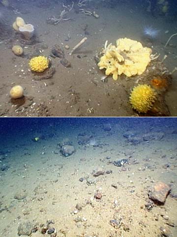
(photo from Les Walting, published in Star Bulletin online edition.)
“The image on the top is from the Mount Desert Rock site. The area has most likely never been trawled and shows abundant life. At bottom, an area in the Gulf of Maine called Truxton Swell has been heavily trawled and shows little visible animal life.”
this gorilla is at least 800 pounds.
Amid the newspaper headlines shouting “SUCCESS” over the missile interception of a faltering US spy satellite in the “middle of the Pacific,” we received the following email from Greenpeace guys. They echoed our concerns about the potential of toxics and debris in the Northwestern Hawaiian Islands:
(from Martini Gotjé, former crew of the GP vessel Rainbow Warrior)
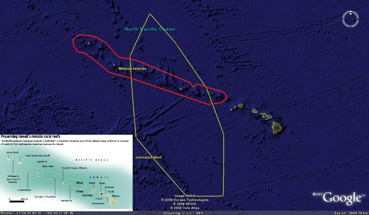
Here are the coordinates of the maritime warning for this sat to be shoot down by Aegis
NAVAREA XII 52/2008(19,83). NORTH PACIFIC. HAWAII. HAZARDOUS OPERATIONS.
1. HAZARDOUS OPERATIONS 210230Z TO 210500Z FEB, ALTERNATE
220230Z TO 220500Z, 230230Z TO 230500Z, 240230Z TO 240500Z
AND 250230Z TO 250500Z FEB IN AREA BOUND BY
31-45N 170-12W, 28-24N 166-42W,
23-52N 163-17W, 19-09N 161-29W,
12-41N 161-29W, 12-39N 165-32W,
18-42N 170-57W, 20-31N 172-30W,
27-03N 172-06W.
2. CANCEL THIS MSG 250600Z FEB.Note that the marine reserve in the NW Hawaiian Island is for a large part covered by this warning area
The toxic hydrazine what the military is talking about is then of no concern for US DoD to land in a reserve with threatened ocean life!!!!!!
See http://www.globalsecurity.org/space/systems/e-305.htm for the real reason why they want to shoot it down. It’s all secret and new technology and they want to make sure that no one can lay their hands on any piece.
He rightly points out that what we’re really talking about is the impacts and implications of expanding militarization of places–of our oceans, of space.
From an article in yesterday’s Hartfort Courant:
“But even as debris from the shattered satellite began raining down over the Pacific Ocean, there were worries that the U.S. achievement might spur other nations to advance their own anti-satellite programs and turn outer space into a potential battlefield.”
And from an article in today’s Australia’s Hearald Sun:
General Cartwright said radar imagery indicated the SM-3 missile hit the satellite’s fuel tank and obliterated the toxic fuel.
“From the standpoint of ‘can I rule out that hazardous material will fall to the Earth?’, not at this point.
This is occurring in a year of Naval training range expansion, undersea warfare exercises, and expanded 2008 RIMPAC wargames. It is also the International Year of the Reef. We’re talking a lot this year about marine debris, overfishing, and ocean acidification and reef death from climate change and warming oceans. Important, for sure.
But can we in Hawaii–currently the most heavily militarized of the 50 states–really talk about healthy reefs and ocean protection without tackling the question of ever-expanding military activities in Hawaiian waters?
Whether we are actively consenting or not, the train is moving. To do nothing is to move with it. We have a limited amount of time to decide–and to act–on the appropriate and humane global uses of lands, ocean, air, and space. At KAHEA, this is another year of doing. We hope you’ll join us.
(map from John Hocevar, missile photo DoD, and monk seal photo credit: James Watt)

